Lidar Spatial Data Analysis - China
price: contact company for price
Feiyan Technology focus on offerring high efficient LiDAR data processing service with Lidar aerial photography and other data.
Lidar, which stands for Light Detection and Ranging, is a remote sensing method that we use light in the form of a pulsed laser to measure variable distances ranges to the Earth.
These light pulses—combined with other data recorded by the airborne system-generate precise, 3D information about the shape and surface characteristics of the Earth.
A LiDAR instrument principally consists of a laser, a scanner, and a specialized GPS receiver.
Airplanes and helicopters are the most commonly used platforms for acquiring lidar data over broad areas.
Two types of lidar are topographic and bathymetric.
Topographic lidar typically uses a near-infrared laser to map the land, while bathymetric lidar uses water-penetrating green light to also measure seafloor and riverbed elevations.
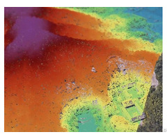
After the LiDAR mapping is done, we start spatial data analysis and processing with self-developed processing software and high processing accuracy.
Specification of LiDAR Spatial Data Analysis
Resolution: ≥0.25 points/m2, >0.2m Project area: 17, 500km² Duration: 3 months Output: Classified point cloud, DEM(1: 10000) Application: National aerospace remote sensing image From: National Geographic Information Center & Henan Provincial Bureau of Surveying, Mapping and Geographic Information
Company Contact:
- Posted By: Feiyan Aerial Remote Sensing Tech Co., Ltd
- Phone: 86-025-83216189
- Address: 8th Floor, Building 3, Xinghe World Industrial Park, 56 Lingzhi Road, Nanjing , Jiangsu , China
- Email:

- Website: https://en.feiyantech.com
Published date: May 31, 2023
- Business Description: Founded in 2003, Feiyan Aerial Remote Sensing Tech Co., Ltd. has been the nation's largest independent geospatial data firm that provides geographic insights to many of the most influential projects in China.
An industry leader in advanced mapping technology, Feiyan delivers the leading data quality with efficiency, while leveraging the most cutting-edge technologies for aerial data acquisitions, geospatial processing/analytics, and GIS visualization solutions.
Related listings
-
 Aerial Integrated Multi SensorInternet - Feiyan Aerial Remote Sensing Tech Co., Ltd - China - May 31, 2023 - contact company for price
Aerial Integrated Multi Sensor The construction of metaverse or 3D scenes is inseparable from basic data, and the richness and quality of data are the keys to determining products. Therefore, as a company specializing in aerial remote sensing for 20 ...
-
 Les Made With Your Design Oem JewelryInternet - GUANGZHOU JINGYING JEWELRY CO.,LTD - China - December 12, 2020 - contact company for price
, focusing on the customization of high-end fashion jewelry wholesale enterprises.Main products include bracelets, bangle, earrings, ear stud, pendants, jewelry sets and other 925 sterling silver jewelry. The custom process of sterling silver pendant...
-
 R40 4g Router Applied To Oil Pipelines Wireless SolutionInternet - King Pigeon Communication Co.,Ltd - China - February 17, 2020 - 111.00 Dollar US$
R40 4G Wireless Router Applied to Oil Pipelines Wireless Monitoring Solution Product description: This router is an industrial IoT high-speed router, compatible with 4G/3.5G/3G/2.5G network, flagship configuration, VPN link, industrial protection, wi...
Safe Trade Tips
- Ask for business references and check them
- Use a payment method that offers better protection for all such as Letters of credit and verified professional escrow services. Avoid payments in advance such as money transfers
- Verify their business via their local Chamber of Commerce
- Search the internet using their website address, their business name, their phone and fax numbers, and their email addresses to see if you can find any feedback about them.
- Get to know more about scams and fraud to avoid: Internet Crime Complaint Center - Consumer Financial Protection Bureau
- This site is never involved in any transaction, and does not handle payments, shipping, guarantee transactions, provide escrow services, or offer "buyer protection" or "seller certification"