Geo Marking Fully Intergrated Gps Surveying Instruments - China
price: contact company for price
The specifications
Model GPS V30
Measurements
220 tracking channels
Advanced Pacific Crest Maxwell 6 Custom Survey GNSS Technology
High precision multiple correlator for GNSS pseudo range measurements
Unfiltered, unsmoothed pseudo range measurements data for low noise, low multipath error, low time domain correlation and high dynamic response
Very low noise GNSS carrier phase measurements with <1 mm precision in a 1 Hz bandwidth
Signal- to- Noise ratios reported in dB- Hz
Proven Pacific Crest low elevation tracking technology
Satellite signals tracked simultaneously
GPS Simultaneous L1C/ A, L2C, L2E, L5
GLONASS Simultaneous L1C/ A, L1P, L2C/ A ( GLONASS M only) , L2P
SBAS Simultaneous L1 C/ A, L5
Galileo Simultaneous L1 BOC, E5A, E5B, E5AltBOC
BDS B1, B2
QZSS L1 C/ A, L1 SAIF, L2C, L5
POSITIONING PERFORMANCE
Static and Fast Static GNSS surveying
Horizontal 2.5mm+0.5ppm RMS
Vertical 5mm+0.5ppm RMS
Post Processing Kinematic
( PPK / Stop & Go) GNSS surveying
Horizontal 1cm+1ppm RMS
Vertical 2.5cm+1ppm RMS
Initialization time typically 10 minutes for base while 5 minutes for rover
Initialization reliability typically > 99.9%
RealtimeKinematic( RTK) surveying
Horizontal 8mm+1ppm RMS
Vertical 15mm+1ppm RMS
Initialization time typically < 8 seconds
Code Differential GNSS positioning
Horizontal 25cm+1ppm RMS
Vertical 50cm+1ppm RMS
SBAS 0.50m Horizontal, 0.85m Vertical
HARDWARE
Physical
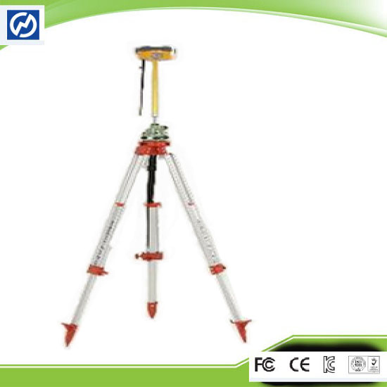
Dimensions ( W x H) 19.50cm x 10.40cm( 7.68 in x 4.09 in)
Weight 1.3kg ( 2.86lb) with internal battery, internal radio, standard UHF antenna
Operating temperature below 45℃ to above 65℃ ( - 49℉ to +149℉)
Storage temperature below 55℃ to above 85℃ ( - 67℉ to +185℉)
Humidity 100% , considering
Water/ dustproof IP67 dustproof, protected from temporary immersion to depth of 1m ( 3.28ft) .
Shock and Vibration Designed to survive a 3m( 9.84ft) natural fall onto concrete
Electrical
Power 6V to 28V DC external power input
Power consumption 2.5W
Automatic Switching between internal power and external power
Rechargeable, removable 7.4V, 5000mAh Lithium- Ion battery in internal battery compartment
Internal battery life
Static 13 - 15 hours
RTK Rover ( UHF/ GPRS/ 3G) 10 - 12 hours
RTK Base 8 - 10 hours
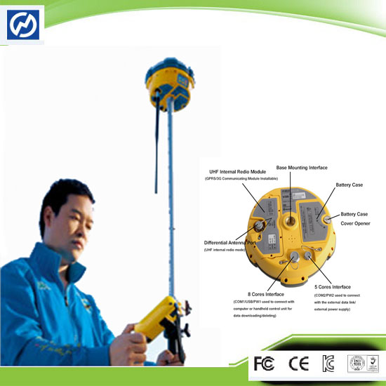
I/ O interface
1 x Bluetooth
1 x standard USB2.0 port
2 x RS232 serial port
2 x DC power input ( 8- pin & 5- pin)
COMMUNICATION AND DATA STORAGE
GPRS/ GSM or 3G
Fully integrated, fully sealed internal GPRS/ GSM or 3G
Network RTK ( via CORS) range20- 50km
HI- TARGET internal UHF radio ( standard)
Frequency
Transmitting Power 0.1W, 1W, 2W adjustable
Transmitting Speed Up to 19.2Kbps
Working Range 3~5Km typical, 8~10km optimal
Pacific Crest XDL micro Internal UHF Radio
Frequency 403~473 MHz
Transmitting Power Up to 19.2Kbps
Working Range 3~5km typical, 8~10km optimal
Support most of radio communication protocol
HI- TARGET External UHF radio ( standard)
Frequency 460 MHz with 116 channels
Transmitting Power 5W, 10W, 20W, 30W adjustable
Working Range 8~10Km typical, 15~20km optimal
Company Contact:
- Posted By: Chongqing Gold Company
- Phone: 8613637882303
- Address: 9F/10,Jintai Building, Nanping , China
- Email:

- Website: https://www.cqtestkit.com
Published date: December 1, 2015
- Business Description: Chongqing Huobo Surveying Instruments Co., Ltd is in producing series of core drilling machine, series of anchor drilling machine, series of engineering drilling machine and directional drilling rig and hydraulic components.
Chongqing Huobo Surveying Instruments Co., Ltd has 4 core businesses involved in surveying GNSS product series, digital sounder series, GIS data acquisition system, marine engineering application integrated system, marine surveying, and marine mapping software products.
Related listings
-
 Dual Frequency Superior Instrument Hi Target Gps Base And RoverGeneral Equipment / Machinery - Chongqing Gold Company - China - December 1, 2015 - contact company for price
The advantages Independence: No external cable or battery is needed, so you can put it where you want. Compatibility: It can both directly transmit and forward in same- frequency or pilot- frequency Multi- channel: It has 116 UHF channels, and suppor...
-
 Bluetooth L1c A L2c Superior Positioning Capability Gnss SystemGeneral Equipment / Machinery - Chongqing Gold Company - China - December 1, 2015 - contact company for price
Bluetooth L1C/ A L2C Superior Positioning Capability GNSS System It is designed to meet high quality standards at an affordable price. It is outstanding in its class, with a rugged design and user- friendly functions. V30 GPS is equipped with a smart...
-
 Professional Linux Operating System Gnss Receiver Rtk SurveyGeneral Equipment / Machinery - Chongqing Gold Company - China - December 1, 2015 - contact company for price
Professional Linux Operating System GNSS Receiver RTK Survey System The V60 is a more compact- design and higher- performance GNSS RTK system, besides its rugged design to resist impact and vibration. The V60 has industrial OLED display screen on its...
Safe Trade Tips
- Ask for business references and check them
- Use a payment method that offers better protection for all such as Letters of credit and verified professional escrow services. Avoid payments in advance such as money transfers
- Verify their business via their local Chamber of Commerce
- Search the internet using their website address, their business name, their phone and fax numbers, and their email addresses to see if you can find any feedback about them.
- Get to know more about scams and fraud to avoid: Internet Crime Complaint Center - Consumer Financial Protection Bureau
- This site is never involved in any transaction, and does not handle payments, shipping, guarantee transactions, provide escrow services, or offer "buyer protection" or "seller certification"